


Embarking on outdoor adventures can be thrilling, but the uncertainty of the terrain can also make it challenging.
Whether hiking up a mountain, exploring an unfamiliar trail, or planning your next mountaineering expedition, knowing your current elevation can be crucial for safety and effective planning.
Yet, carrying additional gadgets like handheld GPS units or topographic maps can be cumbersome and not always precise.
Imagine yourself on a mountain hike. You’ve been going uphill for a while and are curious about how high you’ve climbed, or perhaps you need to know your current altitude for health or safety reasons.
Or maybe, you’re planning your trail route ahead of time and need to anticipate the strenuousness based on elevation gains. Traditional methods might leave you guessing, and guessing isn’t good enough for your safety or enjoyment of your adventure.
Elevation apps provide an easy, precise solution right in your hand. Utilizing the power of modern GPS technology, these apps provide accurate, real-time elevation data, whether you’re online or offline. They simplify your adventures and ensure you’re well-informed at every step of your journey.
This article will explore the best elevation apps, assessing their features, accuracy, and user experience.
Say goodbye to uncertainty, and say hello to well-informed, safe, and enjoyable outdoor experiences.
What To Look For in an Elevation App?🔭
When venturing into the great outdoors, elevation apps can be invaluable for hikers, climbers, and outdoor enthusiasts.

These applications provide crucial information about altitude, terrain, and elevation profiles that can enhance the overall experience and ensure safety during expeditions. However, with many available options, knowing what to look for is important when choosing the right elevation app.
Here are some key factors to consider:-
1. Accuracy:- One of the primary features to prioritize in an elevation app is its accuracy. Look for an app that utilizes reliable data sources and employs advanced algorithms to deliver precise elevation measurements. Accuracy is essential for planning routes, estimating difficulty levels, and determining potential hazards.
2. User-Friendly Interface:- A well-designed and intuitive user interface is crucial for a seamless user experience. Look for an app that presents elevation data clearly and visually appealingly. Interactive maps, customizable features, and easy navigation create a user-friendly experience.
3. Mapping Capabilities:- A comprehensive elevation app should have mapping capabilities that allow users to explore the terrain and view elevation profiles. Look for apps that offer detailed topographic maps with contour lines, shading, and satellite imagery. These features provide a deeper understanding of the landscape and help plan routes.
4. Tracking and Recording:- The ability to track and record elevation data during outdoor activities is valuable. Look for apps that allow users to track their elevation gain, distance traveled, and other relevant statistics. This feature lets users analyze their performance, set goals, and track progress.
5. Offline Accessibility:- When venturing into remote areas with limited connectivity, an elevation app with offline accessibility becomes indispensable. Look for apps that can download maps and elevation data for offline use. This ensures that crucial information is accessible even without an internet connection.
6. Additional Features:- Some elevation apps go beyond basic functionality and offer additional features that enhance the overall experience. These may include real-time weather updates, compasses, sunrise and sunset times, and social sharing capabilities. Consider your specific needs and preferences to choose an app with the right combination of features.
In conclusion, selecting the right elevation app can greatly enhance outdoor adventures. By considering factors such as accuracy, user interface, mapping capabilities, tracking features, offline accessibility, and additional functionalities, you can make an informed decision and choose an app that best suits your needs.
So, before embarking on your next adventure, take the time to find an elevation app that elevates your experience to new heights.
1. AllTrails
When finding the perfect elevation app for outdoor enthusiasts, AllTrails stands out as one of the best choices available for Android and iOS users.
With its impressive features and user-friendly interface, AllTrails has become a go-to app for hikers, trail runners, and nature lovers seeking accurate and detailed elevation information. One of the standout features of AllTrails is its extensive database of trails, which spans various regions and terrains.
Whether looking for a leisurely walk or a challenging ascent, AllTrails offers a vast collection of trails with precise elevation data, allowing users to plan their adventures confidently. The app provides elevation profiles for each trail, highlighting changes in altitude and offering a comprehensive view of the terrain.
AllTrails also offers a robust mapping system that utilizes GPS technology to ensure accurate tracking and navigation.
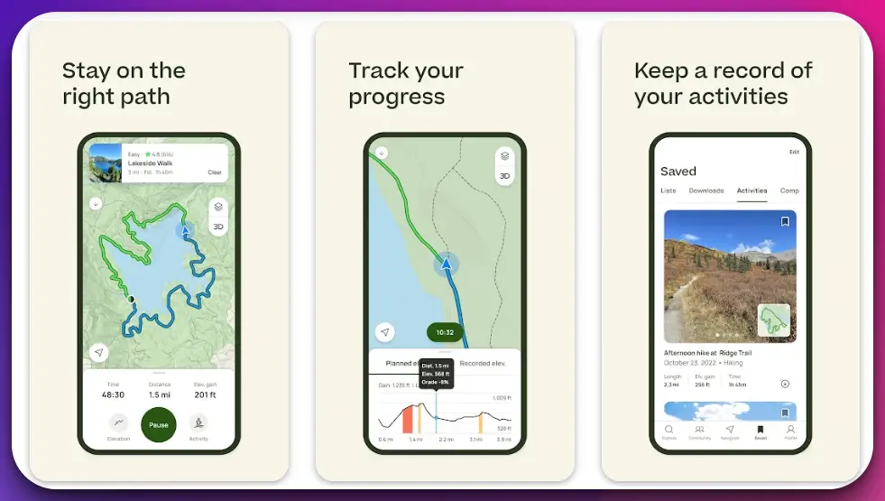
Users can access detailed topographic maps with contour lines and shading, visually representing the elevation changes along the chosen route. This feature helps hikers anticipate steep ascents or descents, enabling them to prepare adequately and make informed decisions while on the trail.
In addition to its mapping capabilities, AllTrails allows users to record their hikes and track important statistics such as elevation gain, distance covered, and pace.
This feature enables users to monitor their progress, set personal goals, and challenge themselves to reach new heights. With the option to download maps for offline use, AllTrails ensures that vital elevation data is accessible even in remote areas with limited connectivity.
Moreover, AllTrails boasts a thriving community of outdoor enthusiasts who contribute trail reviews, photos, and tips, enhancing the overall experience for users.
The app allows users to share their adventures with others, fostering a sense of connection and inspiration among like-minded individuals.
In conclusion, AllTrails is the top choice for an elevation app on Android and iOS platforms. With its vast trail database, accurate elevation information, detailed maps, tracking capabilities, and active community, AllTrails offers an immersive and invaluable experience for outdoor enthusiasts.
Whether you’re a seasoned hiker or a novice explorer, AllTrails is the perfect companion to elevate outdoor adventures.
Pros:-
Extensive Trail Database: AllTrails offers a vast collection of trails with detailed elevation data, providing users with a wide range of options for outdoor exploration.
Accurate Elevation Information: The app provides precise elevation profiles for each trail, allowing users to plan their hikes and anticipate changes in altitude.
Robust Mapping System: AllTrails utilizes GPS technology and topographic maps to ensure accurate tracking and navigation, enhancing the user experience and safety on the trail.
Recording and Tracking Features: Users can record their hikes, track important statistics such as elevation gain and distance covered, and monitor their progress over time, helping them set goals and improve their performance.
Offline Accessibility: AllTrails allows users to download maps for offline use, ensuring that crucial elevation data is available even in areas with limited or no internet connectivity.
Community Engagement: The app has an active community of outdoor enthusiasts who share trail reviews, photos, and tips, fostering a sense of connection and providing valuable insights for other users.
Cons:-
Premium Features: While AllTrails offers a free version with basic functionality, some advanced features, such as offline maps and additional map layers, are only available with a paid subscription.
Limited Coverage: Although AllTrails has an extensive trail database, some remote or less popular areas may have limited trail information.
Battery Consumption: Extensive use of GPS and tracking features can drain device battery life, especially on longer hikes. Users may need to consider power-saving options or carry portable chargers.
Reliance on Technology: Like any technology-based app, AllTrails relies on a stable internet connection and accurate GPS signals, which may be affected in remote or densely forested areas.
User-Generated Content: While the community engagement aspect can be beneficial, the reliability of user-generated content, such as trail reviews, can vary, requiring users to exercise caution and use their judgment.
Overall, AllTrails offers a comprehensive and user-friendly elevation app experience, providing valuable features and accurate elevation information.
The app’s benefits, such as its extensive trail database, mapping capabilities, tracking features, offline accessibility, and community engagement, make it an excellent choice for outdoor enthusiasts.
However, users should consider the limitations, such as the availability of premium features, limited coverage in certain areas, battery consumption, reliance on technology, and the need to verify user-generated content.
User Experience:-
AllTrails offers a seamless and intuitive user experience right from the start. The app’s clean and well-organized interface makes it easy for users to navigate its various features.
Upon opening the app, users are greeted with a search bar where they can enter their desired location or browse through curated lists of popular trails.
Users can access detailed information when searching for a specific trail, including the elevation profile, trail length, difficulty level, and user reviews. The elevation profile visually represents the terrain, allowing users to gauge the ascent and descent along the trail.
Once users select a trail, they can access additional features, such as interactive maps with zooming and panning capabilities. These maps include topographic details like contour lines, shading, and satellite imagery, which help users better understand the elevation changes and surrounding terrain.
AllTrails also offers tracking and recording features that allow users to monitor their hikes in real time. Users can start recording their activities and track statistics such as distance covered, elevation gain, and average pace. These features enable users to record their progress and challenge themselves to improve over time.
Another notable aspect of the user experience is the community engagement within the app. Users can read and contribute trail reviews, upload photos, and share their experiences with others. This creates a sense of community and provides valuable insights for fellow hikers.
Furthermore, AllTrails offers offline accessibility by allowing users to download trail maps and elevation data for offline use. This feature is particularly useful when exploring remote areas with limited connectivity.
Overall, AllTrails offers a highly satisfying user experience thanks to its user-friendly interface, comprehensive trail information, interactive maps, tracking capabilities, community engagement, and offline accessibility.
The app effectively caters to the needs of outdoor enthusiasts, providing them with the necessary tools and information to make their hikes enjoyable, safe, and memorable.
Download The App From Google Play Store
Download The App From Apple App Store
2. Gaia GPS
Gaia GPS is a remarkable choice for adventurers seeking unparalleled functionality and reliability in outdoor navigation apps. Its extensive features and user-friendly interface make Gaia GPS a go-to app for hikers, backpackers, and off-road explorers.
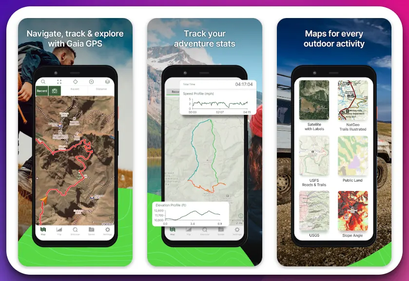
At the heart of Gaia GPS lies its powerful mapping system. Leveraging topographic maps with high-resolution detail, Gaia GPS provides users with a comprehensive understanding of their surroundings.
The app employs advanced algorithms to render accurate terrain contours, ensuring hikers are well-informed about changes in elevation and slope steepness. One of the standout features of Gaia GPS is its versatile waypoint management. Users can easily create custom waypoints, mark important locations, and track progress.
The app allows waypoints to import and export, making it convenient for users to access and share their data across different devices.
Gaia GPS takes data accuracy seriously. It integrates various trusted sources, including satellite imagery and governmental agencies, to deliver the most up-to-date and reliable information. This attention to detail ensures that hikers can confidently plan routes, assess trail conditions, and anticipate elevation changes.
Moreover, Gaia GPS offers a seamless offline experience. Users can download maps and data for a specific area in advance, enabling them to navigate even in regions with limited or no network connectivity. This offline capability is advantageous when exploring remote wilderness areas or embarking on extended expeditions.
Gaia GPS allows users to join adventure communities to enhance collaboration and knowledge sharing. Through these communities, users can access a wealth of information, including trail recommendations, trip reports, and shared waypoints.
This social aspect fosters a sense of camaraderie and inspires individuals to embark on new adventures.
In conclusion, Gaia GPS is a standout app in the realm of outdoor navigation. With its robust mapping system, waypoint management capabilities, emphasis on data accuracy, offline functionality, and community engagement, Gaia GPS empowers outdoor enthusiasts to explore and embark on unforgettable journeys into the wild confidently.
Pros:-
Comprehensive Mapping System: Gaia GPS offers detailed and high-resolution topographic maps, providing users with a comprehensive understanding of their surroundings and elevation changes.
Waypoint Management: The app allows users to create and manage custom waypoints, making it easy to mark important locations, track progress, and share data with others.
Data Accuracy: Gaia GPS integrates trusted sources and employs advanced algorithms to deliver accurate and up-to-date information, ensuring users can rely on the app for route planning and assessing trail conditions.
Offline Functionality: Users can download maps and data for offline use, enabling navigation in areas with limited or no network connectivity, which is particularly beneficial for remote or wilderness exploration.
Community Engagement: Gaia GPS provides access to adventure communities, allowing users to connect with like-minded individuals, share experiences, and gather valuable information and recommendations.
Cons:-
Learning Curve: The app offers extensive features and functionality, which may require time and effort to explore and understand, particularly for new users fully.
Subscription Pricing: While the app offers a free version with limited features, access to advanced functionalities and maps requires a subscription, which may be a drawback for budget-conscious users.
Battery Consumption: Gaia GPS relies on GPS, and continuous use can drain device battery life, especially on longer expeditions. Users may need to consider power-saving options or carry backup power sources.
Limited Live Tracking Features: Gaia GPS does not provide real-time tracking features for sharing locations with others, which may be a drawback for those who prioritize live tracking and safety features.
User Interface: While Gaia GPS offers many features, some users may find the interface slightly complex or overwhelming, especially when first navigating the app’s functionalities.
Despite these minor drawbacks, Gaia GPS remains a powerful tool for outdoor navigation.
Its detailed mapping system, waypoint management, data accuracy, offline functionality, and community engagement make it a reliable choice for hikers, backpackers, and off-road explorers who seek precise and trustworthy navigation capabilities in their outdoor adventures.
User Experience:-
Gaia GPS provides users a seamless and immersive experience that enhances their outdoor adventures. The app’s intuitive interface and thoughtful design make navigating its various features and functionalities easy for users.
When opening Gaia GPS, users are greeted with a clean, organized interface that prioritizes key information. The map view offers many details, including topographic lines, elevation shading, and markers for waypoints and trails.
The app’s responsive and fluid navigation ensures smooth interaction with the maps, allowing users to zoom in and out, pan across the terrain, and switch between different map layers effortlessly.
Users can easily access additional features, such as waypoint creation, tracking, and route planning, with intuitive icons and menus.
Gaia GPS excels in providing users with accurate and reliable data. The app integrates various data sources and algorithms to ensure precise information about elevation, trail conditions, and geographic features. This attention to detail instills confidence in users, enabling them to make informed decisions during their outdoor excursions.
Offline accessibility is another aspect that enhances the user experience. Gaia GPS allows users to download maps and data offline, ensuring possible navigation even in remote areas without network connectivity. This feature is particularly valuable for hikers and backpackers exploring off-the-grid locations.
Furthermore, Gaia GPS fosters community engagement by providing access to adventure communities. Users can connect with fellow outdoor enthusiasts, share experiences, and gain valuable insights and recommendations. This social aspect adds a sense of camaraderie and encourages users to embark on new and exciting adventures.
In terms of performance, Gaia GPS is known for its stability and reliability. The app operates smoothly, and the maps load quickly, even with large data sets. This allows users to focus on their outdoor experiences without interruptions or delays.
Gaia GPS offers a highly satisfying user experience thanks to its intuitive interface, accurate data, responsive navigation, offline accessibility, community engagement, and reliable performance.
The app effectively caters to the needs of outdoor enthusiasts, providing them with a powerful tool for navigating and exploring the great outdoors.
Download The App From Google Play Store
Download The App From Apple App Store
3. Outdooractive ( Previously ViewRanger)
The Outdooractive Hike Ride Trails app is a digital companion for outdoor enthusiasts, designed to transform how they explore the great outdoors.
This app, developed by Outdooractive AG, is a comprehensive tool that caters to various activities such as hiking, cycling, running, and more. With over a million downloads and a commendable rating of 4.2 stars, it has carved a niche in outdoor adventure apps.
One of the standout features of Outdooractive is its high-resolution map display, powered by state-of-the-art vector technology.
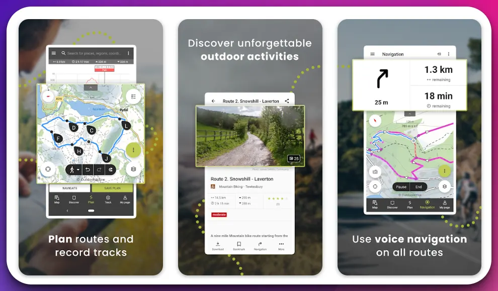
Based on OpenStreetMap, the maps provide detailed and accurate information about trails and routes across the USA. For Pro and Pro+ members, the app offers an expanded selection of outdoor GPS maps, including those from Utah USGS®.
The app’s Route Planner is a game-changer, allowing users to customize trails and routes based on their preferences. This feature and the ability to record personal tracks and trails make Outdooractive a reliable tool for planning and documenting outdoor adventures.
Moreover, the app’s compatibility with Wear OS smartwatches adds a layer of convenience, enabling users to access offline maps and record tracks without needing their phones.
The app also boasts a global hiking trails database, outdoor challenges, and a travel guide, making it a one-stop solution for outdoor activities. However, it’s not without its critics. Some users have expressed dissatisfaction with the app’s interface and functionality, comparing it unfavorably to other apps like Viewranger.
Despite these criticisms, Outdooractive continues to evolve, striving to provide users a seamless and enriching outdoor experience.
Pros:-
Wide Range of Activities: The app supports various outdoor activities such as hiking, cycling, running, and biking, making it a versatile tool for outdoor enthusiasts.
High-Resolution Maps: The app offers a high-resolution display of maps at all zoom levels, providing detailed and accurate information about trails and routes.
Route Planner: The Route Planner allows users to plan and create trails and routes based on their preferences, enhancing the user experience.
Tracking Functionality: Users can record their tracks and trails, including duration, distance, altitudes, and an interactive altitude profile.
Compatibility with Wear OS and Apple Watch: The app is compatible with smartwatches with Wear OS from Google and apple watch os. It allows users to save offline maps to their watch and use it in standalone operation.
Global Hiking Trails Database: The app includes a global hiking trails database, providing users with a wide range of trail options.
Cons:-
Interface and Functionality: Some users have expressed dissatisfaction with the app’s interface and functionality, finding it less intuitive than similar apps.
Comparison with Other Apps: The app has been unfavorably compared to other apps like Viewranger, with some users finding the latter more user-friendly and functional.
Limited Free Features: While the app does offer a range of features, some of the more advanced features, such as access to certain maps, are only available to Pro and Pro+ members.
Ads and In-App Purchases: The app contains ads and offers in-app purchases, which some users might find intrusive or inconvenient.
User Experience:-
The user experience of the Outdooractive Hike Ride Trails app seems to be a mixed bag based on the information available.
On the positive side, the app offers various features that outdoor enthusiasts appreciate. The high-resolution maps, route planner, and tracking functionality are particularly praised for their usefulness in planning and executing outdoor activities.
The compatibility with Wear OS and Apple watch smartwatches is also a plus, allowing users to access offline maps and record tracks without needing their phones.
However, some users have expressed dissatisfaction with the app’s interface and functionality. The app has been unfavorably compared to other apps like Viewranger, with some users finding the latter more user-friendly and functional.
Some users have found the interface less intuitive than they would like, making navigating and using the app’s features more difficult.
Additionally, ads and the need for in-app purchases to access certain features could negatively impact the user experience. Some users might find these aspects intrusive or inconvenient, detracting from the overall enjoyment of the app.
In conclusion, while the Outdooractive Hike Ride Trails app offers a range of features that can enhance outdoor activities, the user experience could be improved regarding interface design and functionality. The developers might need to consider user feedback to make the necessary improvements.
Download The App From Google Play Store
Download The App From Apple App Store
4. PeakVisor
PeakVisor stands tall as a true trailblazer in the realm of elevation apps, offering many features that make it one of the best elevation apps available. With its innovative technology and user-friendly interface, PeakVisor transforms outdoor enthusiasts’ engagement with mountains and elevations.
At the core of PeakVisor’s brilliance lies its groundbreaking augmented reality (AR) capabilities. The app leverages advanced computer vision algorithms to recognize and label mountain peaks in real-time through the camera lens.
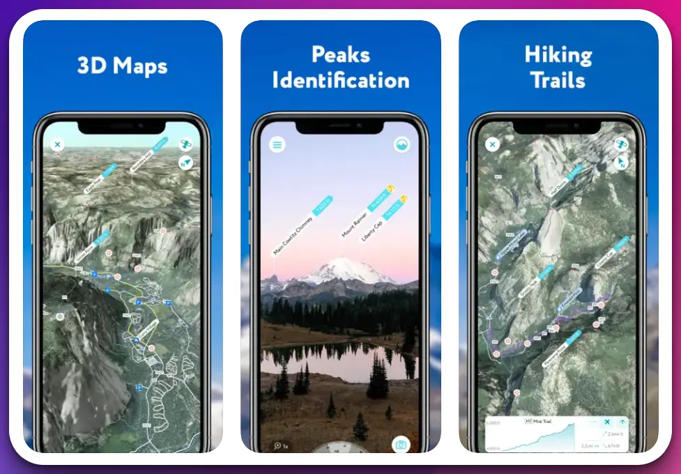
This unique AR experience brings mountains to life, providing users with fascinating insights into nearby peaks’ names, altitudes, and distances.
PeakVisor goes beyond AR to deliver an impressive database of mountain information. Users can explore and discover mountains worldwide with access to a vast collection of global topographic maps and elevation data. The app provides accurate elevation profiles and detailed statistics, allowing hikers, climbers, and nature lovers to plan their adventures precisely.
Furthermore, PeakVisor offers seamless integration of its features with GPS technology. Users can track their location, navigate trails, and view their current elevation in real-time.
The app’s offline functionality ensures that users can access essential data even in remote areas without internet connectivity, making it an indispensable tool for wilderness exploration.
PeakVisor’s commitment to user experience is evident in its visually stunning and intuitive interface. The app’s user-friendly design allows for smooth navigation, easy access to features, and seamless switching between AR mode and map view.
Users can also save and organize their favorite mountains, creating personalized collections to revisit and explore at any time.
In conclusion, PeakVisor redefines the elevation app landscape with its innovative AR technology, comprehensive mountain database, GPS integration, offline functionality, and user-friendly interface. For outdoor enthusiasts seeking a truly immersive and informative experience in exploring elevations, PeakVisor stands as the pinnacle of excellence.
Pros:-
Augmented Reality Experience: PeakVisor’s unique AR technology lets users visually identify and label mountain peaks in real time, providing an immersive and interactive experience.
Extensive Mountain Database: The app offers a vast collection of global topographic maps and elevation data, allowing users to explore and discover mountains from various regions worldwide.
Accurate Elevation Profiles: PeakVisor provides precise elevation profiles and detailed statistics, enabling users to plan their outdoor adventures accurately and confidently.
GPS Integration: The app seamlessly integrates with GPS technology, allowing users to track their location, navigate trails, and view real-time elevation information.
Offline Functionality: PeakVisor offers offline access to essential data, ensuring users can access important mountain information even in areas without internet connectivity.
User-Friendly Interface: With its intuitive design and easy navigation, PeakVisor provides a user-friendly experience, making it accessible to users of all levels of expertise.
Cons:-
Limited Coverage: While PeakVisor’s mountain database is extensive, it may not include every mountain peak worldwide. The app may not identify some lesser-known or remote peaks.
AR Limitations: The accuracy of the augmented reality feature can be influenced by various factors, such as lighting conditions and the visibility of mountain peaks. Users may experience occasional difficulties in AR recognition.
Device Compatibility: PeakVisor’s AR capabilities require devices with compatible hardware and software. Older or less advanced devices may not support the full AR functionality of the app.
Subscription-based Model: PeakVisor offers a free version with limited features, but access to the full range of features and advanced functionality requires a paid subscription.
Battery Consumption: Using the AR and GPS features of PeakVisor may drain device battery life more quickly, particularly during extended outdoor use. Users may need to manage power-saving options or carry backup power sources.
Despite these limitations, PeakVisor’s innovative AR technology, extensive mountain database, accurate elevation profiles, GPS integration, offline functionality, and user-friendly interface make it a compelling choice for elevation enthusiasts.
The app offers a unique and engaging experience, enabling users to explore and appreciate mountains in a new way.
User Experience:-
PeakVisor delivers an exceptional user experience, combining innovative features and a user-friendly interface to provide outdoor enthusiasts with a captivating and informative journey into the world of elevations.
One of the standout features of PeakVisor is its augmented reality (AR) experience. Users can point their device’s camera toward a mountain peak, and the app’s advanced computer vision algorithms instantly recognize and label the peak in real time.
This AR capability brings mountains to life, offering an immersive and interactive way to engage with the surrounding landscape.
The app’s extensive mountain database is another aspect that enhances the user experience. Users can explore a vast collection of topographic maps and access accurate elevation profiles of mountains worldwide.
Whether planning a hike, admiring the view, or learning about the surrounding peaks, PeakVisor provides valuable information and statistics at users’ fingertips.
PeakVisor integrates with GPS technology, enabling users to track their location, navigate trails, and view real-time elevation information. This integration enhances the user experience, ensuring precise positioning and reliable elevation data during outdoor adventures. Additionally, PeakVisor’s user-friendly interface contributes to a seamless experience.
The intuitive design allows for effortless navigation between AR mode and map view, making it easy for users to switch between different features and access information.
Offline functionality is another notable aspect of PeakVisor. Users can download maps and data offline, ensuring crucial information is accessible even in remote areas without network connectivity. This feature enhances the app’s usability and reliability, making it a valuable tool for wilderness exploration.
Overall, PeakVisor offers a highly engaging and informative user experience. The combination of its augmented reality experience, extensive mountain database, GPS integration, user-friendly interface, and offline functionality provides outdoor enthusiasts with an immersive and empowering tool to explore and appreciate elevations like never before.
Download The App From Google Play Store
Download The App From Apple App Store
4. My Altitude
In the realm of GPS-based applications, My Altitude stands as a paragon of utility and precision. This ingenious creation by Dayana Networks Ltd is a testament to the power of technology in our hands, transforming our smartphones into a veritable Swiss Army knife of geographical and meteorological tools.
My Altitude harnesses the power of GPS signals to pinpoint your location with remarkable accuracy, providing real-time data on latitude, longitude, and altitude.
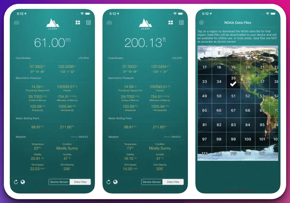
This data is not merely a set of coordinates; it is a gateway to understanding your environment in a way that was once the preserve of seasoned explorers and cartographers.
The application’s capabilities extend beyond mere location tracking. It delves into the realm of barometric pressure and even the boiling point of water at your current location.
While seemingly esoteric, this information can be invaluable for outdoor enthusiasts, hikers, and climbers, providing a deeper understanding of the environment and how it might affect physical performance or cooking at high altitudes.
In a world where advertisements often intrude on the user experience, My Altitude offers a refreshing approach. The app is free and without limitations, with an optional in-app purchase to remove advertisements, a testament to the developers’ commitment to user-centric design.
My Altitude is a shining example of how technology can enhance our understanding and interaction with the world around us. It is not just an app; it is a tool, a guide, and a companion for those who venture into the great outdoors.
Pros:-
Versatile Functionality: My Altitude provides a wide range of information, including latitude, longitude, altitude, barometric pressure, and water boiling point. This makes it a comprehensive tool for outdoor enthusiasts.
Offline Use: The app does not require an internet connection, making it ideal for use in remote areas with sparse network coverage.
Free to Use: My Altitude is free to download and use, with no limitations on its functionality. This makes it accessible to all users.
User-Friendly Interface: The app is designed to be easy to use, with a clear and intuitive interface.
In-App Camera Feature: The ability to take a picture of your location and watermark it with location and altitude information is a unique and useful feature.
Cons:-
Accuracy Dependence on Device: The accuracy of the altitude measurement depends on the device’s sensor, which may not be as accurate on older devices.
Advertisements: The free version of the app includes advertisements. While there is an option to remove these via an in-app purchase, some users may find them intrusive.
Limited Weather Information: While the app provides some weather information, it is less comprehensive than dedicated weather apps.
Requires GPS: The app requires GPS to function, which can drain the device’s battery faster.
User Experience:-
The user experience of the My Altitude app is largely positive, with several features designed to enhance usability and provide valuable information.
Upon opening the app, users are greeted with a clean, intuitive interface that displays their current location, altitude, barometric pressure, and the boiling point of water at their location. The information is presented in a clear, easy-to-read format, making it accessible even for those unfamiliar with such data.
One of the standout features of the app is its offline functionality. This is particularly useful for hikers, climbers, and outdoor enthusiasts who often find themselves in areas with limited or no internet connectivity.
The app’s ability to function without an internet connection ensures that users can access important location and altitude data wherever they are.
The in-app camera feature is another highlight, allowing users to photograph and watermark their location with their coordinates, altitude, and local date/time. This feature adds an element of fun to the app and allows users to share their adventures with others.
However, the user experience is not without its drawbacks. Advertisements in the free version of the app can distract some users. Additionally, the accuracy of the altitude measurement can vary depending on the device’s sensor, which may lead to inconsistent results for some users.
The My Altitude app offers a user-friendly experience with many useful features. While there are some areas for improvement, the app’s benefits largely outweigh its drawbacks, making it a valuable tool for anyone needing location and altitude data.
Download The App From Google Play Store
Download The App From Apple App Store
5. Topo Maps+
Topo Maps+ emerges as a dynamic and feature-rich app that brings the world of topographic mapping to users’ fingertips. With its extensive functionality and intuitive interface, Topo Maps+ empowers outdoor enthusiasts with unparalleled access to detailed terrain information.
At the core of Topo Maps+ lies its comprehensive collection of topographic maps. These maps provide users with precise and detailed information about the terrain’s contours, elevations, and features.
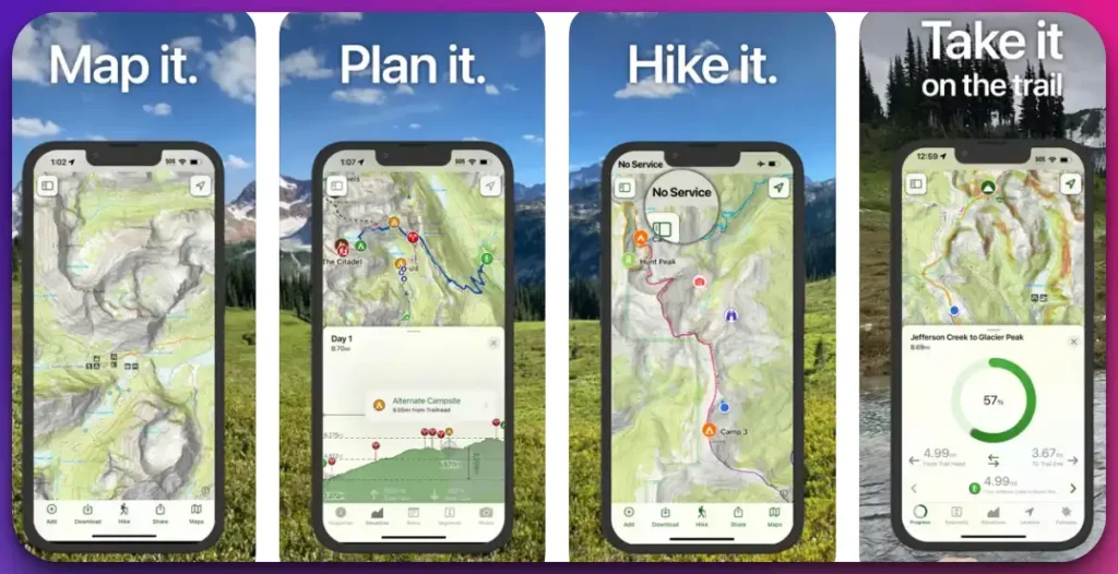
The app enables users to confidently navigate, plan routes, and gain a deeper understanding of their surroundings by utilizing advanced cartographic techniques.
One of the standout features of Topo Maps+ is its versatility. Whether users are hiking, backpacking, cycling, or other outdoor activities, this app caters to their needs.
It offers a diverse range of map overlays, including satellite imagery, shaded relief, and land cover data, enriching the map view and providing users with a comprehensive landscape perspective.
Moreover, Topo Maps+ goes beyond traditional mapping capabilities by offering advanced features such as route planning, tracking, and waypoint management.
Users can plan their adventures, create custom routes, and track their progress in real-time. The app allows for easy recording and sharing of tracks and waypoints, enhancing collaboration and facilitating the exchange of experiences among users.
Topo Maps+ further excels in its offline functionality. Users can download maps and data for offline use, ensuring reliable access to vital information even in areas with limited or no network connectivity. This feature proves invaluable when exploring remote or off-grid locations.
In conclusion, Topo Maps+ is a formidable tool for outdoor enthusiasts seeking to unlock the power of topographic mapping. With its extensive topographic maps, versatile map overlays, advanced route planning and tracking features, and offline functionality, Topo Maps+ elevates the outdoor experience, empowering users with the knowledge and tools to navigate and explore confidently.
Pros:-
Comprehensive Topographic Maps: Topo Maps+ offers a wide range of detailed topographic maps, providing users with precise information about contours, elevations, and terrain features.
Versatile Map Overlays: The app offers various map overlays, including satellite imagery, shaded relief, and land cover data, enhancing the visual representation of the landscape and providing users with a comprehensive perspective.
Advanced Features: Topo Maps+ provides advanced features such as route planning, tracking, and waypoint management, enabling users to plan, record, and share their adventures effectively.
Offline Functionality: Users can download maps and data for offline use. This ensures reliable access to vital information even in areas with limited or no network connectivity, making it ideal for remote or off-grid exploration.
User-Friendly Interface: Topo Maps+ features an intuitive interface that is easy to navigate, allowing users to easily access and utilize its various features.
Cons:-
Subscription Model: Topo Maps+ operates on a subscription-based model, which may be a drawback for users looking for a free or one-time purchase option.
Learning Curve: The app offers a wide range of features and functionalities, which may require time and effort for users to explore and understand fully.
Battery Consumption: Extensive use of GPS and map features can drain device battery life, especially during prolonged outdoor activities. Users may need to manage power-saving options or carry backup power sources.
Limited Coverage: While Topo Maps+ provides extensive topographic map coverage, certain regions or less popular areas may have limited or incomplete data.
Reliance on Technology: The app relies on a stable internet connection and accurate GPS signals, which may be affected in remote or heavily forested areas.
Overall, Topo Maps+ offers a robust topographic mapping experience with its comprehensive maps, versatile overlays, advanced features, offline functionality, and user-friendly interface.
While it has a subscription model and may have a learning curve, the app provides a valuable tool for outdoor enthusiasts seeking detailed and reliable terrain information.
User Experience:-
Topo Maps+ provides users with a seamless and immersive user experience that enhances their outdoor adventures. The app’s user-friendly interface, comprehensive features, and intuitive design create a smooth and engaging experience.
When users open Topo Maps+, they are greeted with a visually appealing and organized interface. The app’s intuitive layout and easy-to-navigate menus allow users to access the desired features effortlessly. The clean design focuses on the maps and terrain information, making exploring and interacting with the app a breeze.
Topo Maps+ excels in providing users with detailed topographic maps. The app’s comprehensive collection of maps offers precise information about contours, elevations, and terrain features.
Users can zoom in and out, pan across the maps, and explore various overlays to understand the landscape better. The app’s versatility is another notable aspect of the user experience. Topo Maps+ caters to various outdoor activities, including hiking, backpacking, and cycling.
Thanks to the app’s advanced features, users can easily plan their routes, create custom tracks, and manage waypoints. The ability to track progress in real-time adds a layer of engagement and enables users to monitor their performance.
Topo Maps+ offers offline functionality, allowing users to download maps and data for use in areas with limited or no network connectivity. This feature ensures that users have access to vital information even when exploring remote or off-grid locations.
In conclusion, Topo Maps+ provides a highly satisfying user experience. Its user-friendly interface, comprehensive topographic maps, versatile features, and offline functionality provide a seamless and immersive outdoor navigation experience.
With Topo Maps+, users can confidently explore the terrain, plan their adventures, and maximize their outdoor pursuits.
Download The App From Apple App Store
6. My Elevation
In digital topography, RDH Software’s My Elevation app emerges as a paragon of precision and utility. This application harnesses the power of web services to deliver exact surface elevation data, a feat that transcends the capabilities of conventional devices.
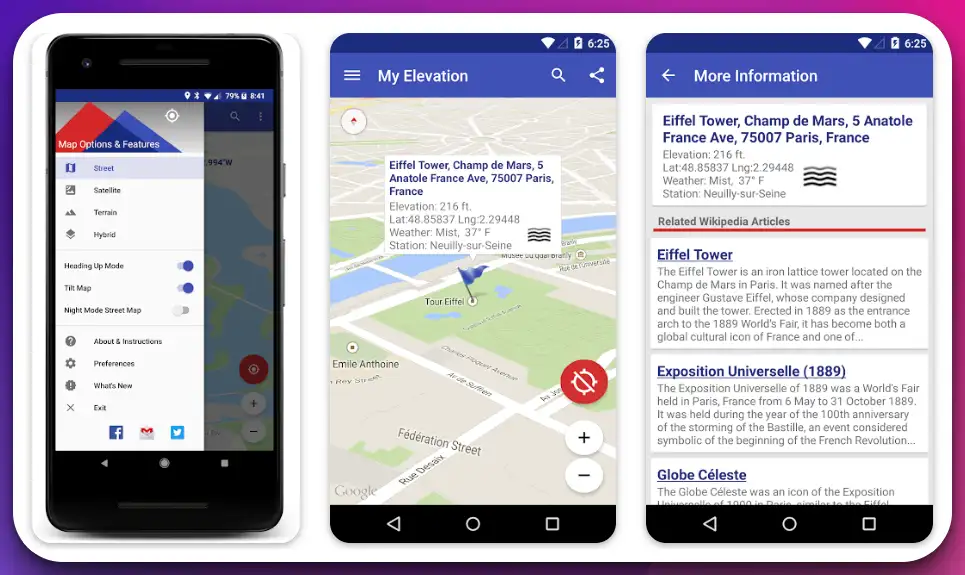
The apps Follow Me Mode is a testament to real-time tracking, dynamically updating elevation and coordinates in sync with the user’s movements. This feature, a symphony of technology and convenience, paints a vivid picture of one’s journey through varying altitudes.
My Elevation doesn’t stop at mere location tracking. It extends its functionality to encompass a comprehensive exploration of any searched location. The app swiftly flies to the queried location, unveiling the weather and a treasure trove of information about nearby attractions via Wikipedia articles.
The long-press feature further enhances the user’s interaction with the map. A simple long press on any location unfurls a wealth of knowledge about the weather and local attractions, transforming the app into a virtual tour guide.
The ability to bookmark locations and share discoveries via text or email adds a layer of personalization and social interaction. Whether it’s a memorable spot or an intriguing find from a search, sharing and remembering are just a tap away.
My Elevation is a beacon of innovation in the digital age, transforming how we perceive and interact with our geographical surroundings. Its fusion of precision, information, and user-friendly features makes it a must-have tool for the modern explorer.
Pros:-
Precision: My Elevation uses web services to provide accurate surface elevation data, surpassing the capabilities of standard devices.
Real-time Tracking: The Follow Me Mode offers real-time tracking of your location, updating your elevation and coordinates as you move.
Comprehensive Information: The app provides detailed information about any searched location, including the weather and nearby attractions, via Wikipedia articles.
User-friendly Features: The ability to bookmark locations and share discoveries via text or email adds a layer of personalization and convenience.
Cons:-
Data Connection Dependency: The app requires a working data connection to function, which may limit its usability in areas with poor or no internet connectivity.
No Offline Mode: The lack of an offline mode can be a significant drawback for users who frequently travel to remote areas.
Limited Altitude Information: The app does not provide altitude data in cases where you are in an aircraft, high up in a building, or high off the ground.
Data Privacy Concerns: The app shares location data with third parties and collects app activity and info, which may raise privacy concerns for some users.
User Experience:-
The user experience of the My Elevation app is largely positive, as evidenced by its impressive 4.8-star rating on the Google Play Store.
Users appreciate the app’s precision in providing surface elevation data, which is more accurate than standard devices. The real-time tracking feature, Follow Me Mode, is highly praised for updating elevation and coordinating dynamically with the user’s movements.
The app’s ability to provide comprehensive information about any searched location, including weather and nearby attractions, via Wikipedia articles adds significant value to the user experience.
The long-press feature and the ability to bookmark locations and share discoveries via text or email are also well-received, enhancing the app’s usability and personalization.
However, the app’s dependency on a data connection and lack of an offline mode have been pointed out as areas for improvement. These limitations can hinder the app’s functionality in areas with poor or no internet connectivity.
Additionally, the app’s inability to provide altitude data in certain scenarios and its data privacy practices may also affect the user experience for some individuals.
Despite these drawbacks, the overall user experience of the My Elevation app is highly rated, making it a popular choice for users seeking precise and comprehensive elevation data.
Download The App From Google Play Store
How To Maximize the Use of Elevation Apps
Elevation apps have revolutionized outdoor exploration, providing users with valuable information about altitude, terrain, and navigation.
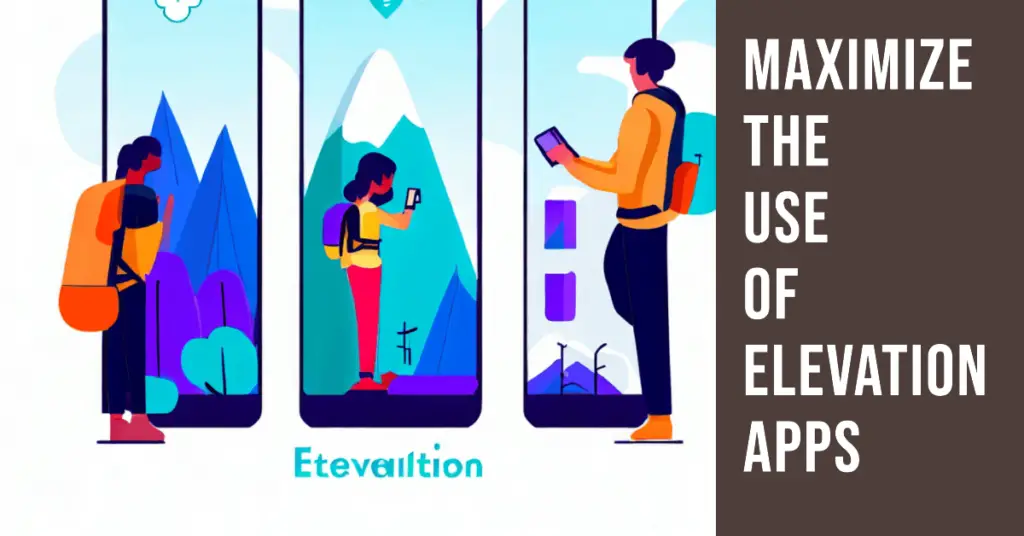
To fully harness the power of these apps and elevate your outdoor experiences, here are some key strategies to maximize the use of elevation apps:-
1. Get to Know the Features
Take the time to familiarize yourself with the features and functionalities of your chosen elevation app. Explore the app’s interface, understand how to access elevation data, and learn to utilize additional tools such as route planning, tracking, and waypoint management. Knowing the full range of features will help you maximize the app’s capabilities.
2. Customize Settings
Tailor the app’s settings to your preferences and specific needs. Adjust units of measurement to match your preferred system (feet, meters, etc.), choose the desired map overlays (such as satellite imagery or topographic details), and optimize GPS accuracy settings. Customizing the app’s settings will enhance its performance and align it with your outdoor pursuits.
3. Download Offline Maps
Before embarking on outdoor adventures, download maps and data for offline use. This ensures you can access critical elevation information even in areas with limited or no network connectivity. Downloading offline maps allows you to navigate confidently and plan routes without relying on a continuous internet connection.
4. Plan Ahead
Use the app’s features to plan your outdoor activities effectively. Study elevation profiles, identify potential challenges, and assess the difficulty level of trails. Take advantage of features like trail ratings and user reviews to choose suitable routes for your skill level and preferences. Planning helps you make informed decisions and ensures a smoother outdoor experience.
5. Record and Analyze
Utilize the app’s tracking and recording features to monitor your outdoor activities. Track key statistics such as elevation gain, distance covered, and pace. Recording your hikes, runs, or other outdoor pursuits allows you to analyze your progress, set personal goals, and track improvements over time. This data can be valuable for training, exploring new trails, and measuring your achievements.
6. Engage with the Community
Many elevation apps have built-in community features where users can share experiences, provide trail reviews, and offer recommendations. Engaging with the community allows you to tap into a wealth of local knowledge and gain insights from fellow outdoor enthusiasts. Connect with like-minded individuals, share your experiences, and discover new trails or hidden gems recommended by other users.
7. Battery Management
Elevation apps can be power-intensive, especially when utilizing GPS and tracking features. To conserve battery life, optimize your device’s power settings. Adjust the screen brightness, close unnecessary background apps, and consider carrying a portable charger or extra batteries for longer outdoor adventures. Maximizing battery life ensures that your elevation app remains functional throughout your journey.
8. Learn Map Symbols
Take the time to learn and understand the symbols and icons used on topographic maps within the elevation app. These symbols represent various terrain features, landmarks, and hazards. Understanding these symbols will help you interpret the map more effectively and confidently navigate.
By following these strategies, you can maximize the use of elevation apps and unlock their full potential in your outdoor pursuits.
Whether hiking, backpacking, or engaging in other outdoor activities, leveraging the features and functionalities of elevation apps will enhance your navigation, planning, and overall outdoor experiences. Embrace the power of elevation apps and elevate your adventures to new heights.
📗FAQ’s
What is the best app for finding elevation?
Regarding finding elevation, one of the best apps available is Topo Maps+. It offers a comprehensive range of features and detailed topographic maps, allowing users to easily determine their current altitude and explore elevation data for various locations.
Is there a free app for elevation?
Yes, there are free apps available for finding elevation. One such app is My Altitude, which provides accurate elevation readings and additional features without requiring a subscription or payment.
Can my iPhone detect my elevation?
Yes, iPhones have built-in sensors that can detect elevation. IPhone apps such as My Altitude can accurately determine your current altitude by utilizing GPS and barometric pressure sensors.
Can I measure elevation with my phone?
Absolutely! With the help of elevation apps like Topo Maps+ and My Altitude, you can measure elevation using your phone’s built-in sensors and GPS technology.
Can Google Maps show the elevation profile?
Yes, Google Maps can display an elevation profile for a chosen route. By right-clicking on the map and selecting “Measure distance,” you can view the elevation changes along your selected path.
How do I get Google Maps to show elevation?
To view elevation on Google Maps, follow these steps: Right-click on the starting point of your desired route, select “Measure distance,” then click along the route to add points. The elevation profile will be displayed on the left side of the screen.
How accurate are elevation apps?
Elevation apps, such as Topo Maps+ and My Altitude, provide accurate elevation data. However, it’s important to note that accuracy may vary based on factors such as GPS signal strength, sensor calibration, and the quality of the elevation data used by the app.
How accurate is smartphone GPS elevation?
Smartphone GPS elevation readings can be reasonably accurate, especially with barometric pressure data. However, factors such as atmospheric conditions and signal interference can somewhat affect accuracy.
How accurate is Google elevation?
Google’s elevation data is derived from various sources and is considered reasonably accurate. However, it is advisable to use dedicated elevation apps or devices for precise measurements.
Is there a device that reads elevation?
Yes, specialized devices called altimeters are designed to read elevation accurately. These devices use barometric pressure sensors to measure changes in air pressure and calculate altitude.
How do I see elevation on Google Maps on iPhone?
To view elevation on Google Maps on an iPhone, follow the steps mentioned earlier for a desktop. Right-click on the starting point, select “Measure distance,” and add points along your desired route to see the elevation profile.
How do I find out my elevation?
To find your elevation, you can use apps like My Altitude or Topo Maps+, which utilize GPS and barometric pressure sensors to determine your current altitude accurately.
How do you find the elevation between two points?
You can use Google Maps or dedicated elevation apps like Topo Maps+ to find the elevation between two points. By selecting the starting and ending points, you can obtain the elevation profile and understand the changes in altitude along the route.
What is the most accurate GPS for elevation?
Dedicated handheld GPS devices, such as those from Garmin and Suunto, are known for their accurate GPS elevation readings. These devices often employ multiple sensors and advanced algorithms to provide precise elevation data.
Does the compass app show elevation?
The compass app on most smartphones typically focuses on providing direction rather than displaying elevation. To view elevation, it is recommended to use dedicated elevation apps or other mapping applications.
Why is my GPS elevation not accurate?
Various factors can affect the accuracy of GPS elevation readings. These include signal interference, atmospheric conditions, limitations of the GPS hardware, and errors in the elevation data used by the app or device.
At what altitude do you lose your phone signal?
The altitude at which you might start to lose phone signal can vary depending on factors such as proximity to cell towers, terrain, and network coverage. Signal strength may decrease as you ascend to higher elevations or enter areas with limited infrastructure.
Which mobile phone has the best GPS accuracy?
Several mobile phones, including Apple, Samsung, and Google flagship models, offer excellent GPS accuracy due to advanced GPS chipsets and signal processing algorithms. It is advisable to research and compare the GPS capabilities of different phone models before deciding.
What is the most accurate elevation data?
Elevation data from government sources, such as national mapping agencies or geological surveys, is often considered the most accurate. These sources collect data using various methods, including airborne lidar scanning and ground-based surveys.
Does GPS read elevation?
Yes, GPS technology can provide elevation readings by using satellites to triangulate your position and calculate the distance from the Earth’s surface. However, some elevation apps combine GPS data with other sensors, like barometric pressure to improve elevation readings for greater accuracy.
Conclusion
In the realm of outdoor adventure, knowledge, and preparation are key. Our exploration of the top elevation apps has unveiled tools that provide accurate and real-time data and enhance our experiences in the great outdoors. These apps eliminate the need for guesswork, equipping us with vital information at our fingertips.
Whether you’re a novice hiker or a seasoned mountaineer, these apps cater to various needs, from simple altitude checks to complex trail planning.
The power of technology, as exhibited by these elevation apps, has undoubtedly transformed how we interact with and explore our natural world.
Remember, safety and enjoyment go hand in hand with outdoor activities. Equip yourself with a reliable elevation app that suits your needs, and you’ll find yourself reaching new heights and creating memorable experiences.
As we conclude, we’d love to hear from you. Share your experiences and thoughts on these apps and how they’ve influenced your outdoor adventures.
Happy exploring, and may you always have the joy of reaching your peak!