


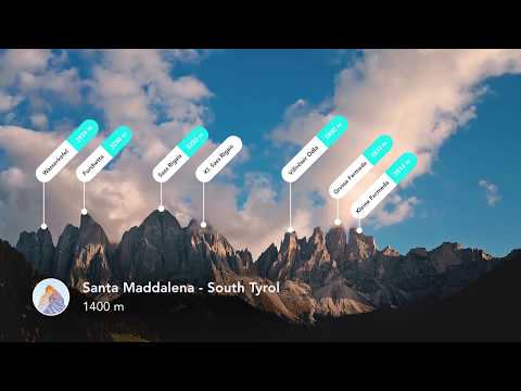
Most of you may already be familiar with the term ‘hiking.’ Hiking is primarily an activity where one goes on a long walk. However, certain elements distinguish it from the plain act of walking. Hiking is usually done on rough terrains where walking is comparably harder.
Originating from Europe, this activity has grown and is a common practice. It is not a sport, and it is done for pleasure.
Hiking is also seen as a form of exercise or working out, as not only it requires endurance and stamina, but it also improves both of them if practiced regularly.
There are a bunch of preparations you need to make before you decide to go hiking. One of them is planning your hike.
Understandably, the pleasure of hiking lies in exploring new, unseen places and discovering things you didn’t know existed. Still, a planned hike will be more meaningful in terms of experience than an unplanned one.
Whether it is a nearby forest, mountain footing, or hilly area, you must plan your hike thoroughly to make the most out of your hiking trip and, most importantly, for a safe trip.
Several mobile applications on the internet will help you with your hiking trip, and we’ve shortlisted the best among them.
In this article, we’ll look at the best hiking apps you can install on your smartphone to ensure that your hiking trip is safe and that you enjoy a great hiking experience.
Why the need for hiking apps?🤔
Some might think, why the need for such apps anyway? To an extent, it is acceptable that an unplanned hike gives a lot of thrills and is more fun. However, we should consider other things besides thrill and fun.
Our safety, the best route for hiking, locations nearby, recommended gear, and other things are equally important. In this section, we’ll discuss some of the perks of hiking apps, which are greatly helpful in making our hiking trip worth it.
Getting ideas for hiking:- It will let you know about the best hiking spots around you. You can also find hiking spots in locations that are distanced from you.
These apps will let you learn about some of the best hiking locations that can give you a great hiking expert. You can use these apps even to plan routes and stops, thus proceeding smoothly with your hiking trip.
Navigation:- As mentioned earlier, it is important to consider our safety while planning a hiking trip. These apps will assist you in choosing the best possible route for your hike based on the internet’s information. This will ensure your safety all the time and will eliminate the possibility of getting lost.
Knowledge:- Hiking is all about discovering new stuff you weren’t aware of. These apps have useful info on the best hiking locations. They’ll give you details about certain plants and wildlife. These apps will educate you about hiking-related things you didn’t know before.
Keeping track of your performance:- As mentioned earlier, hiking is a form of exercise. It will give you important info such as distance covered, calories burnt, total time taken, pace, etc. All this information can be really helpful in deciding your overall performance during hiking.
Now that we’ve covered the reasons to use these apps, let’s look at some of the great hiking apps we’ve shortlisted for you.
Best Hiking Apps – Our Top Pick👌👌
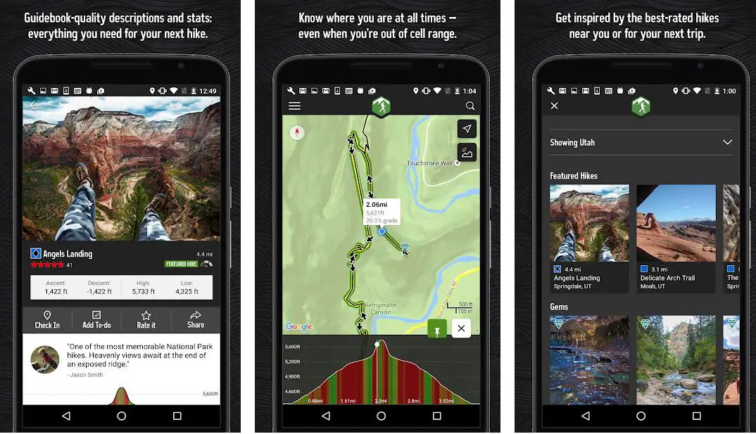
1. AllTrails – Best apps for finding hiking trails
The first application on our list of best hiking apps of all time is AllTrails. This application is easily one of the top contenders for the position of the best hiking app ever, and its features justify our statement.
Packed with numerous features, this app is our greatest ally for hiking. The catalog of this application is full of nearby destinations for hiking and even other activities like biking, horse riding, backpacking, and running.
The GPS activity tracker of this app is useful for keeping a tab on our hiking activity.
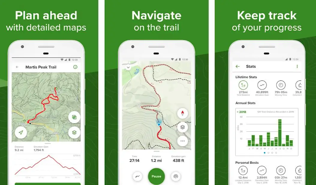
Besides that, the app gives you access to the AllTrails community, a community where one can find plenty of inspiration for their next hike.
AllTrails will give you information about the hiking locations and spots around your location, and you’ll also get to use a trail map for navigation.
Trail maps are great tools for navigation while hiking or cycling. It has hundreds of trail maps and maps you can download offline for navigation.
With this feature, you can kiss goodbye to the possibility of getting lost in an unknown location. There is a feature called Lifeline in the pro version of the AllTrails app that lets you assign safety contacts.
These safety contacts will be aware of your hiking plan and will be able to keep track of your progress. The AllTrails application also updates air quality, pollen concentration, satellite weather, and light pollution. This is useful info that will aid you in preparation for your hiking trip.

AllTrails app comes with a pro version as well. The pro version offers some extra features for an annual subscription.
Lifeline, ad-free user interface, off-route notifications, and real-time map overlays are some features included in the pro version of AllTrails.
Download the App from Google Play Store
Download the App from Apple App Store
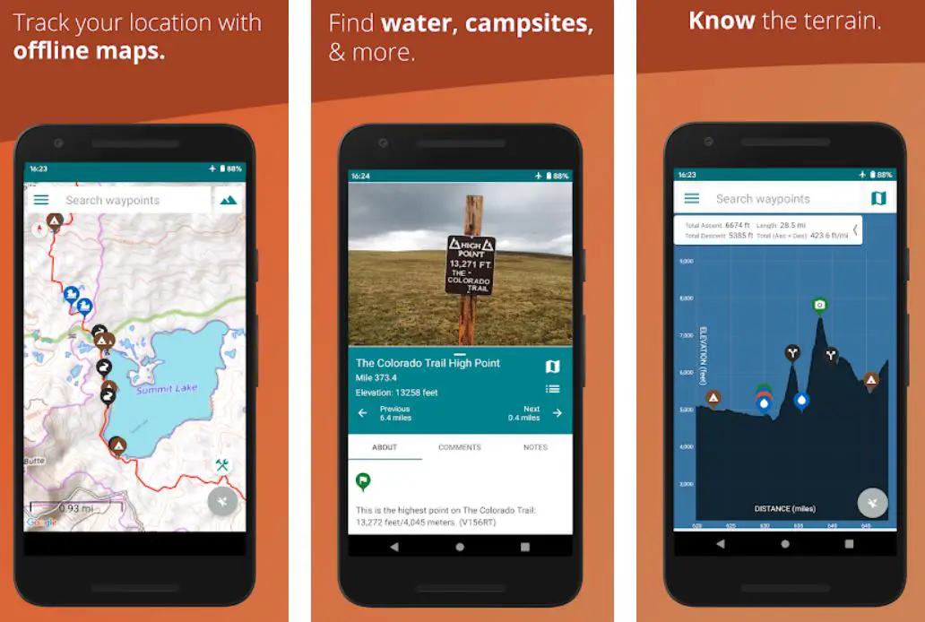
2. Gaia GPS: Hiking, Offroad Maps
TrailBehind develops it., Gaia GPS is your ally for accurate navigation and hike planning. Like the AllTrails application, the Gaia GPS app also features trail maps for its users, making navigating through almost all sorts of locations a piece of cake.
Gaia GPS app was designed with the latest cutting-edge technology and is a perfect tool for planning a hiking trip.
The best part about Gaia GPS is that this application is not just about hiking. This app works as a single solution for various activities such as hunting, camping, skiing, exploring, and hiking.

This is why Gaia GPS features maps and trails that are constantly monitored and updated quickly. This is why the accuracy of Gaia GPS is second to none.
This app also acts as your guide on your hiking trip, suggesting locations to set up your camp or nodes for marking checkpoints.
Depending on the location, Gaia GPS may also assist you in finding nearby resources such as water bodies.
Besides that, several features of this app are meant for activities other than hiking. This application is a one-time solution for almost every activity that involves exploration.
Be it camping, Overlanding, mountaineering, mountain biking, skiing, trekking, and hiking; the Gaia GPS is likely to be a complete package of assistance that’ll guide you throughout the journey. In terms of GPS tracking and navigation, the accuracy this app comes with is exceptional.
Some features come with only the premium membership of this app. These include downloading maps for offline viewing, satellite imagery, weather forecasts, etc.
The free version of Gaia GPS works perfectly fine, but with the premium subscription, you’ll get many more features to enhance your hiking experience.
Download the App from Google Play Store
Download the App from Apple App Store
3. Outdooractive (Formerly ViewRanger)
Outdooractive is an app slightly different from the other hiking applications in this article. We’ll discuss what makes it different later in this section.
Outdooractive is primarily a massive navigation application that inspires exploration. The community is full of itineraries that are helpful and will assist you in finding the best routes and locations for hiking.
You’ll find the community eagerly sharing their hiking experiences and info, which you can take into account to enhance your overall hiking experience. You’ll also get to share your hiking experience and info with others.
The route navigation feature is one of the most useful features of ViewRanger. Route navigation uses the GPS tracking system in our smartphone to accurately tell our present location by the route we chose, with all of the extra information needed to complete a hiking trip safely.
The route navigation feature will also allow you to choose and mark certain points along the route that can be used as a stoppage, camping spot, or waypoint.
The route navigation feature will highlight them in real-time during your journey, which in a way, will also help you avoid getting lost.
Now let’s talk about the feature that differentiates ViewRanger from other hiking applications. This application is equipped with augmented reality technology that allows you to navigate and view the terrain in 3D.

Regarding activities like hiking, this feature is of great use and eliminates the possibility of getting lost. The AR feature of ViewRanger is its best-selling point.
Besides that, it is also equipped with guidebooks that will educate you about several things along your planned route. ViewRanger, especially because of its AR viewing feature, is a strong contender for the spot of the best hiking applications.
Download the App from Google Play Store
Download the App from Apple App Store
4. Google Maps
You have probably been living under a rock if this is the first time you’ve heard the name of this globally used application. Google maps is a worldwide navigation application that has more than many of us know.
It is the biggest navigation application out there, and the database of this application is simply massive.
You can say that almost no corner of this world is hidden from it. This is precisely why this application is a great tool for hiking enthusiasts.
The feature of downloading maps offline is often underestimated, and many apps charge for a premium membership or for a pro version to give this feature.
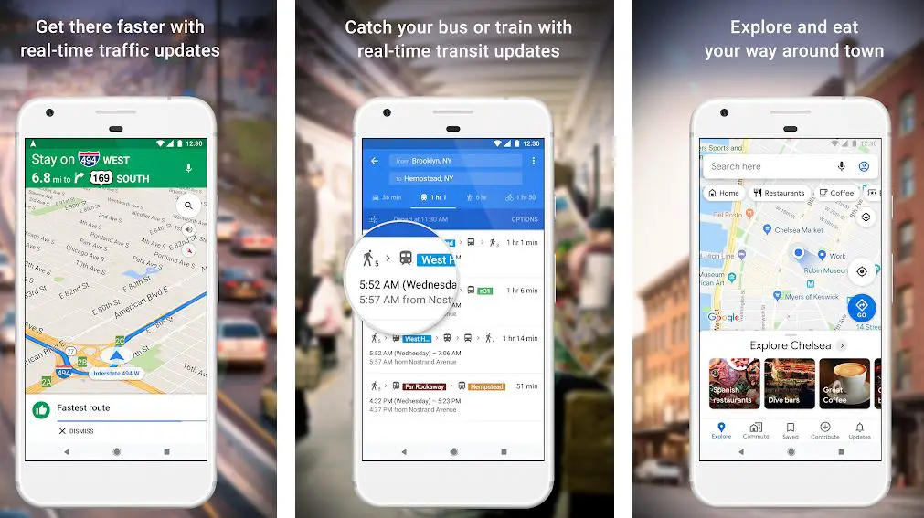
However, Google Maps offers the feature of downloading maps offline and saving them for later for no price whatsoever. You can download a map, choose your waypoints, devise a trail, or simply follow a trail that already exists.
Yes, that’s right. Popular trails in hiking locations in Google Maps are also shown to others. This way, you’ll know the route you’re planning to take is entirely safe.
Besides the super accurate GPS tracking system, one of the most useful features of this app is the feature that allows you to download an offline trail map that you can customize as per your choice. This is where things get interesting.
You can design a route for yourself as per your choice in any location once you choose a certain point as your starting location and then choose an endpoint. You can download this customized route offline and view it later whenever you go for exploration.

This will help you stay on the way always, so you don’t have to worry about getting lost. All these features make Google Maps one of the best hiking apps available on the internet.
Download the App from Google Play Store
Download the App from Apple App Store
Wikiloc is a rather simple hiking apps gps application, which is precisely what makes it ideal. It is an application that lets you view topographic maps from across the globe without any data usage. Yes, you read that right.
You’ll be able to access any of the hundreds of topographic maps available on the Wikiloc app without an internet connection.
This makes it an ideal navigation app for hiking, as often, during hiking, people end up at places where the internet doesn’t work or is weak.
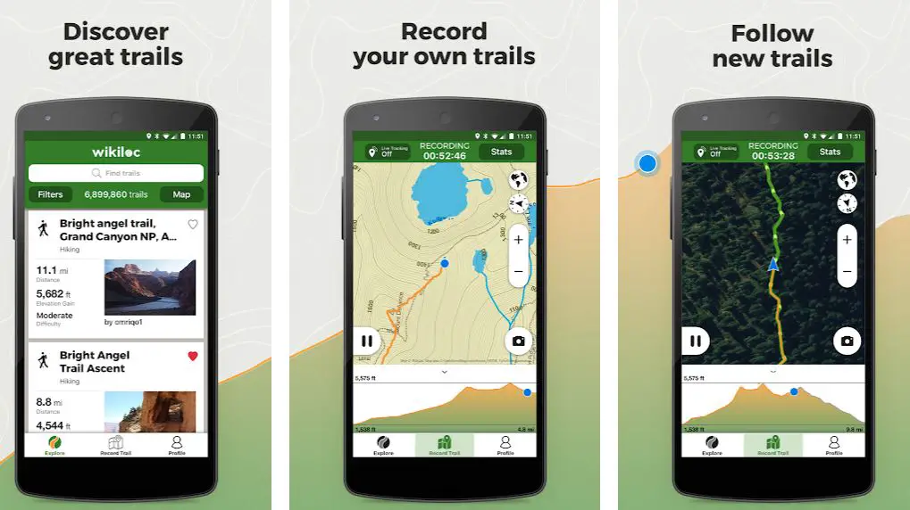
With the help of Wikiloc, you won’t have to worry about getting lost or not knowing the way ahead of you. You can simply access the topographic map and find a way out without data usage.
Before using this app, you’ll need to create and register an account. You can share this account with your close contacts, letting them know about your hiking routes and plans.
Not only that, Wikiloc provides you with over 70 activities that you can choose from, extract information, and view trails/maps based on that information.
These activities include hiking, running, biking, MTB, skiing, etc. Depending on your choice, you can record routes, add waypoints and share that info on the internet via the Wikiloc app.
With an internet connection, you can choose to share information such as your current location and the route you took with your family in case things take an unexpected turn and you feel the need for some help. Wikiloc is equipped with features that will ensure your safety to a great extent.
Aside from the features mentioned so far, Wikiloc has features like live tracking, weather forecast, finding existing trails, advanced search filters, etc.
Viewing topographic maps without the need for the internet can be a lifesaver and is indeed the best feature of Wikiloc.
Download the App from Google Play Store
Download the App from Apple App Store
6. PeakVisor: 3D Maps & Peaks Identification
PeakVisor is another unique app in this list of best hiking apps. The app is best suited for activities like mountaineering and hiking.
It is packed with tones of useful features, some of which are super cool and give a futuristic touch to navigation. Let’s take a look at some features of PeakVisor.
PeakVisor gives you access to many topographic maps from worldwide that are greatly detailed and accurate. The terrain modeling in these maps is precise, making navigation easier.
You can view maps in 3D for a better experience, and it effectively give you an insight into the complete area.
However, this app’s main attraction is the mountain identification feature. Using the latest image recognition technology with your phone’s GPS, PeakVisor can identify and name mountains/mountain peaks in your phone’s camera range. This feature has more to it than it seems on the surface.
Along with the name of the mountain peak, PeakVisor will also display a detailed profile analysis of them, giving you an accurate idea of the situation of the environment around you. You can also access educational info PeakVisor draws from the internet after quickly recognizing the mountain peak.
As far as hiking is concerned, the 3D map feature of PeakVisor has all of it settled. You can see a vast network of hiking trails in hiking locations near you. You can also see spots that act as waypoints or camping spots while hiking.
Also, all of the data available on PeakVisor is downloadable so that it can work perfectly fine with no internet connection.
Using features like trail maps, GPS tracking, and route navigation, your hiking trip will be a safe and memorable experience.
Download the App from Google Play Store
Download the App from Apple App Store
7. Hiking – Guthook Guides
If we talk about popularity, this application far surpasses any other hiking-centric application on the internet. Guthook Guides is known for having over 35,000 miles of trails stored in its databases, and you know what that means.
You can easily find multiple trails around your location using Guthook Guides, which will make devising a route for your hike a piece of cake.
The information stored in its databases makes this app ideal for hiking.
Hikers design this app so they know what they seek. The trails on this app come with a lot of extra yet important information.
This information includes locations of waypoints along the trail, spots ideal for camping or stoppage, distance, elevation, water sources, and other topographic information. All this detailed information will make you plan your hike thoroughly, and you won’t have any unnecessary concerns.
Guthook Guides uses our phones’ GPS service to provide an elevation profile view and a detailed navigation route. We also can create a custom route for our trip. This feature is of great help when we want to hike in new, unexplored locations.
The data this application provides, along with the locations of waypoints, is quite detailed and covers everything that counts as important info while setting up a waypoint or a camp.
Guthook Guides have access to hundreds of trails all across the globe. However, you’ll have to purchase each trail individually, or you can also choose to buy the full trail guide.
The app is still completely free to use, but you’ll have to purchase in-app trails to use or plan your hike. Except for the trails, all of the features mentioned in this section are free in the Guthook Guides app.
Download the App from Google Play Store
Download the App from Apple App Store
8. FATMAP: Hike, Bike, Ski Trails – 3D outdoor maps
As the name suggests, FATMAP is mainly used for navigation and route planning. FATMAP is a feature-packed application ideal for hiking and other outdoor activities.
This application is a great tool for mountain sports and hiking. Equipped with precise and accurate 3D maps of almost all hiking locations around your area, this application is all you need for your navigation needs while hiking.
The 3D maps in this application are constantly updated and in sync with real-time information. The best part about using FATMAP for planning a route is that this app will use your preferences and choices to devise a route that best suits them.
It means that the route FATMAP will suggest is the best possible route for you. You can also choose the type of activity before deciding on a route that will help FATMAP to find a more apt route. Besides hiking, the activities included in FATMAP are mountain biking, trail running, resort skiing, backcountry skiing, etc.
FATMAP also offers the feature of offline maps. You can download these maps and plan routes to ensure your hiking plan goes smoothly and uninterrupted.

Satellite imagery is a feature not many pay much attention to, but when it comes to hiking in mountain regions, they have plenty of significance.
Satellite imagery in FATMAP is of great quality and accuracy in both seasons, summer and winter. This application is equipped with advanced terrain analysis tools, which are super effective in navigation.
The app also lets you keep a tab on your adventure and record it for recollection.
Download the App from Google Play Store
Download the App from Apple App Store
9. MyTrails
Developed by FrogSparks, MyTrails is an ideal application for hiking. What differentiates it from other applications in this list is that it has zero ads, and you don’t have to pay anything to achieve that.
Surely there are certain in-app purchases, but the app is free to use and features no advertisements.
It is equipped with an orientation map that uses our smartphones’ GPS service to navigate in real time.

While hiking, the app will also display details such as altitude and speed while displaying tracks. Topographic maps in MyTrails are greatly accurate, and we also get the option of saving them for later use.
The app lets you add waypoints to your trails while navigating, a useful feature. Other than that, you’ll get access to offline maps as well.
Your planned route will be displayed precisely with your added waypoints and will alter in real-time as you move along the route. With a simple and ad-free user interface, MyTrails is an apt contender for the spot of your hiking ally.
Download the App from Google Play Store
10. Hiking Project
This is probably the simplest, most forward navigation app on this list of best hiking apps. It has a massive 74,000 miles of trail data stored, and the maps shown in this app are greatly detailed.
Planning a route using the Hiking Project is rather easy, and the route planner will constantly receive real-time updates. Trail maps are highly precise and detailed.
The elevation profile feature of the Hiking Project is far more detailed than any other app in this list.
Hiking Project will search and tell you about the best hikes around your location, and it will even provide you with several possible routes you can choose as per your choice and preference.
You can also track your location along the planned route using this app via your phone’s GPS service. The Hiking Project truly is the ideal application for hiking.
Download the App from Google Play Store
Download the App from Apple App Store
11. Cairn: Hiking & Outdoor Trail Safety
Next, we have Cairn. These apps for hiking trails can record your route, find cell coverage spots, download maps for offline use, and get stats about your route.
It is one of the best map apps for navigating the wild and is filled with different features. For instance, you will get to enjoy the live tracking feature.

You can share your GPS location with your contacts during a trip or hike. So in case if something happens to you, your loved ones will get to know about it. They will also get important information needed to make informed rescue initiation decisions.
In addition, you can download topo maps designed specifically for outdoor pursuits. Plus, you will be able to get live distance, elevation gain, ETA stands for 4000+ hiking routes and more.
Moreover, the app is pretty flexible, and you can use it for hiking and backpacking, trail running, skiing, cycling, rock climbing, camping, and more.
What’s more? The app can be downloaded and is available for Android and iOS devices. However, some features of the app are only available to premium users.
Download the App from Google Play Store
Download the App from Apple App Store
12. PeakFinder
PeakFinder is another feature-rich app for hiking that you can download. However, the app is only made for people who love mountains. So if you plan a trip to the mountains, the app will help you find the perfect spot.
The app provides a 360-degree panorama showing all the peaks and mountains. Also, it works completely offline and is available worldwide.
Additionally, the app is aware of more than 850’000 peaks from all across the globe. So you can find information about any hill or mountain next to your place or around the globe.

As far as the app’s features are concerned, the app works offline and offers you a real-time rendering of the surrounding landscapes in a range of 300km/200mil.
Also, it offers you a digital telescope that lets you select less prominent peaks. You can select a viewpoint by GPS, showing the solar and lunar orbit with the rise and set times, and so on.
However, unlike the other names, the app is not free to download. Instead, you will need to purchase the app to get started with it. But yes, it only has a one-time fee and has an affordable price tag.
Download the App from Google Play Store
Download the App from Apple App Store
13. OS Maps: Explore hiking trails & walking routes
Next, there is the OS Maps. This app is only available if you are planning to explore Great Britain. As it only offers you outdoors saturated in Great Britain.
You can use the app to walk, hike, bike, run or ramble across stunning paths throughout the Great British countryside.
It allows you to find local paths and walking routes. Along with that, you will be able to find new and exciting map routes and discover amazing cycling and hiking routes.
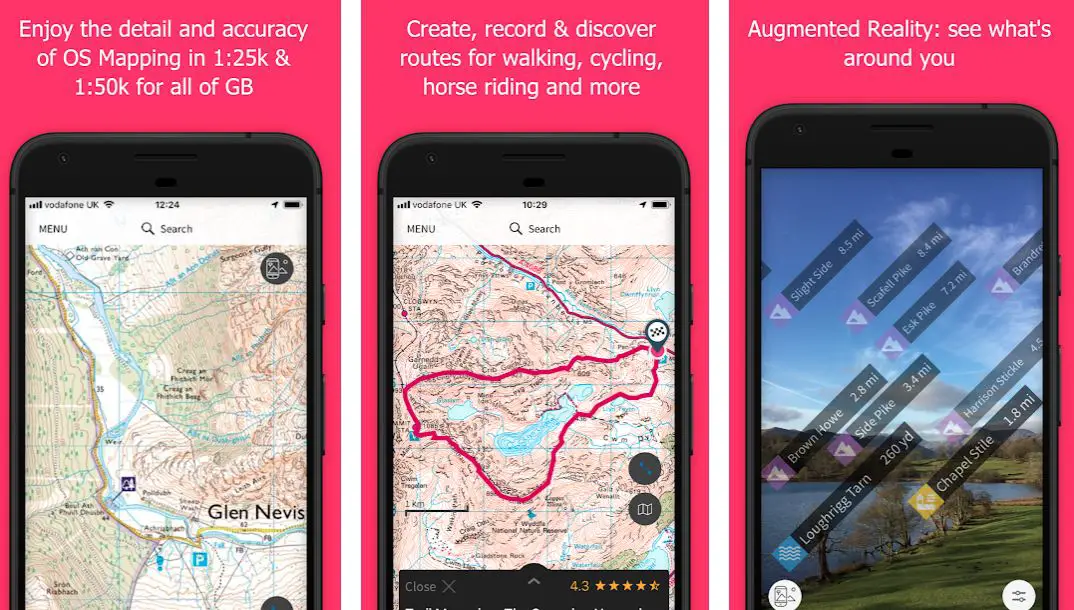
However, most of the features on the app are available to paid users. And if you switch to the premium plan, you can unlock the detail and accuracy of OS leisure maps across the country.
Plus, you can view, create and sync your activities between desktop and mobile. Using a desktop, you can use a 3D Aerial Layer to plan a route, see the terrain, explore in stunning 3D with route fly-throughs and print maps, and has many other features.
Download the App from Google Play Store
Download the App from Apple App Store
14. Recreation.gov
Recreation.gov is the best app you can try out if you are into camping. The app is made for discovering American camping areas.
And it offers you a one-stop solution to finding unique camping destinations. You can easily return to your favorite spot or discover a new one by searching for the campsite.
Plus, you can find and book campsites and experiences using the app. You can also review location details for your trip and quickly access information on existing reservations from almost anywhere.
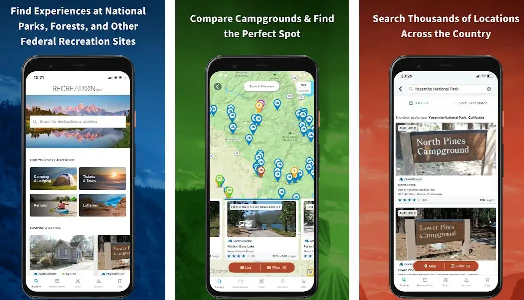
Moreover, it also lets you search for unique campgrounds and individual campsites across the country. You can even discover personalized recommendations based on your location, filter search results by what is important to you, and more.
Even you can view photos and maps of campgrounds and campsites. So you will be able to know about a spot better.
What’s more? The app also offers you real-time availability and location information for individual sites, pay for select campsites and activities on the spot by scanning a QR code, learn about passes and tickets that get you into your favorite spots, and more.
Download the App from Google Play Store
Download the App from Apple App Store
15. Spyglass: GPS, compass, and maps toolkit
For my next pick, I have the Spyglass. This one is an essential offline GPS app for outdoor and off-road navigation. It comes with lots of tools that help you to navigate in a better way.
For instance, it can be used as binoculars, heads-up displays, hi-tech compass with offline maps, GPS receivers, and more. Plus, it saves custom locations and navigates you precisely to your location.
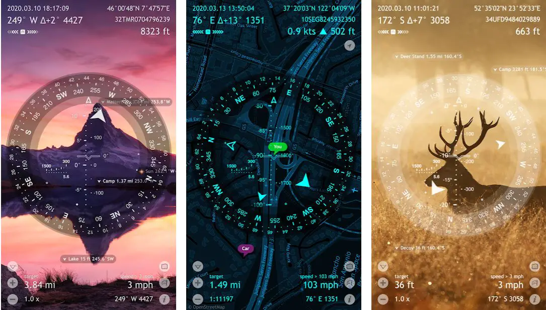
Also, it shows maps and uses augmented reality to show you detailed GPS info and measures distances, sizes, angles, and so on. Moreover, it comes with special compass modes and calibration methods that offer you an accurate and advanced digital compass.
The 3D augmented reality feature will show your location’s object positions, info, and directions.
Also, you can use the app to save your current position, add a point from maps or manually enter location coordinates. You can also use the app to track Polaris, Sun, and Moon positions with arc-second precision.
So you can use these data points to calibrate the compass for maximum accuracy. What’s more? The app is free to download and is available for Android and iOS devices.
Download the App from Google Play Store
Download the App from Apple App Store
16. Komoot: Cycle, Hike, MTB, Run
You can also have a look at the Komoot. This is also one of best hiking apps available out there. The app allows you to plan your hiking, road cycling, or mountain bike adventure.
Along with that, it offers you turn-by-turn GPS voice navigation. So you can keep your focus on the road and not on the app.

It also allows you to download your planned outdoor map. So you can go to hiking paths where there is no network availability. Plus, you can differentiate hiking trails, singletracks, paved roads, mtb trails, terrain, and land cover with one glance.
Moreover, you can also see the Komoot community’s favorite places and highlights on the trail map. So you can find spots for snack breaks or find good places to visit as you like.
As well as the app is free to download and use. Also, it allows you to sync your mobile app with a desktop app. So you can plan your route on a computer and sync it to your Android or iOS devices.
Even it supports a bunch of other devices. Such as Garmin, Wahoo, Sigma, Bosch, and others.
Download the App from Google Play Store
Download the App from Apple App Store
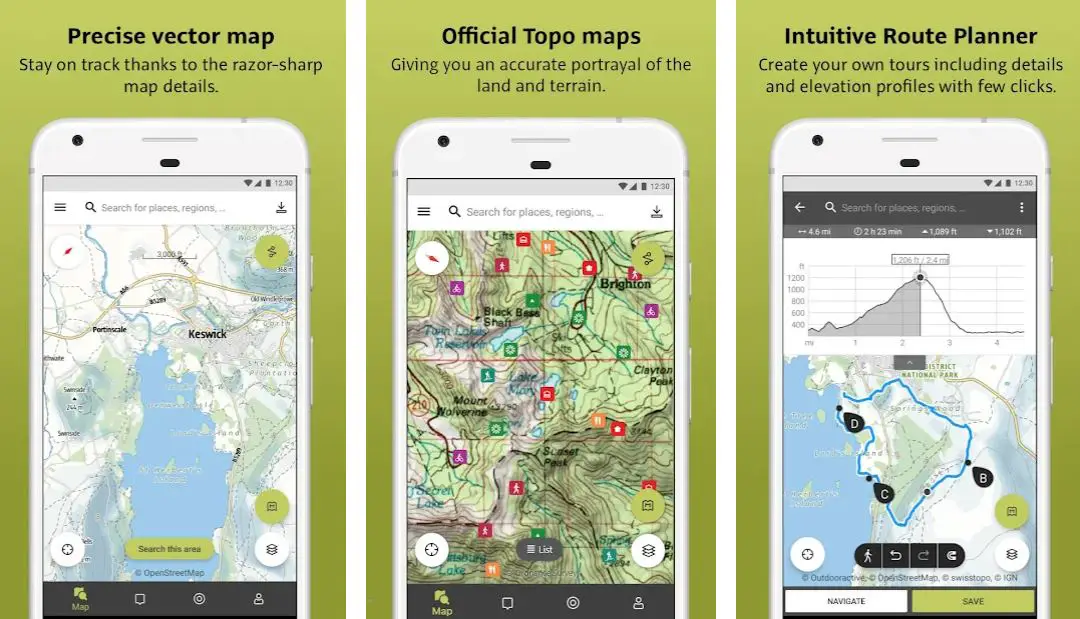
17. Outdooractive
Next, there is Outdooractive. This is also one of the top apps to help you plan your hiking, cycling, mountaineering, or other outdoor activities.
The app comes with the latest vector apps that offer accurate hiking and cycling trail details. Also, you will get to know about the protected areas and information about other outdoor activities.
It also has a global database of trails. So you can find newer hiking, cycling, and skiing spots with full details, elevation profiles, directions, and photos. Moreover, with its Route Planner, you can plan and create routes based on your preferences.
Also, you can add text and photos to your maps and publish them within the community or share them with your friends or family. So if you are planning a trip with your friends, this feature would be helpful.
You can also record your tracks, including duration, distance, and an interactive altitude profile. Moreover, you can download the app for free, which is available for Android and iOS devices. However, some features are only available to premium users.
Download the App from Google Play Store
Download the App from Apple App Store
📗FAQ
What Is The Best App For Hiking?
Various apps can be used for hiking. AllTrails, FarOut, Gaia, OnX Backcountry, Hiking Project, National Park Service, iNaturalist, iOverlander, and Runkeeper.
These apps are available on Android as well as on iOS. You can download these apps from the App Store on your iOS device or the Play Store on your Android Device.
What Is A Hiking App?
A hiking app is used to navigate the trails and find the best route to your destination.
Also, these apps can help you track your hikes and provide you with all the necessary details about every hike, such as duration, distance, locations, etc.
If you love hiking and go on hiking trips now and then, you will need a Hiking app installed on your phone.
How Can I Track My Hike On my iPhone?
You can use the Map My Tracks app to track your hike on an iPhone. This app provides a high-performance all-sport GPS tracker that is easy, fun, and motivating.
There are various other Hiking apps that you can prefer using if you don’t want to use Map My Tracks or are looking for an alternative.
Is The AllTrails App Worth It?
Yes, it is a good app to find out the best trails that are present around you. You can also see those trails’ reviews and keep track of the location while hiking.
Also, if you buy the premium version of this app, you will find many benefits to using it.
What Is The Use Of Hiking Apps?
Hiking apps are very useful for saving hikes that have been done for some years, and also they keep track of where they are and what they are called.
Using these apps, you can learn more about the trails and the areas you are exploring.
Is Google Maps A Good App For Hiking?
You can track your hike using Google Maps. Using Google Maps, you can easily track your progress in busy places also.
This app is not always reliable for less popular trails. You can download offline maps and use them if hiking on a route with poor internet connectivity.
Verdict
In this article, we went over some of the best hiking applications on the internet available for our smartphones. Hiking is a fun activity that involves a lot of thrill, energy, and surprises.
It is important to plan many things before hiking, and planning a route is also crucial. The apps mentioned in the list are shortlisted based on their functionality and usage.
These applications will ensure you get the best out of your hiking experience while ensuring your safety.